Be a part of the Deep South Challenge research rōpū, and help enable Aotearoa New Zealand to prepare for our changing climate.
We are now seeking funding proposals for our Domains Research. We’re looking to fund research that will enable climate-sensitive sectors – hapū and iwi, business, and local and central government – to adapt to climate change.
Funding proposals are due 8 November 2019 with an expected start date of 1 April 2020.
We invite proposals to:
the Māori domain
the three domains of Communities, Infrastructure and the National Economy.
MĀORI DOMAIN
We are looking for research projects that will contribute substantive and transformative outcomes for Māori and for wider Aotearoa New Zealand. These must fit within the Challenge’s mission, to enable New Zealanders to anticipate adapt, manage risk, and thrive in a changing climate.
Please find all the documentation you need to submit a research proposal at this section of our website.
COMMUNITIES, INFRASTRUCTURE, NATIONAL ECONOMY DOMAINS
We are calling for research that focuses on: making and improving projections of New Zealand’s future climate; the impacts and implications of climate change for Aotearoa New Zealand; and enabling adaptation to climate change.
Research proposals should address the research themes of multiple impacts, effective adaptation, water and land and the economy.
Please find all the documentation you need to submit a research proposal at this section of our website.
We look forward with anticipation to your innovative, high-impact and end user-relevant research proposals.
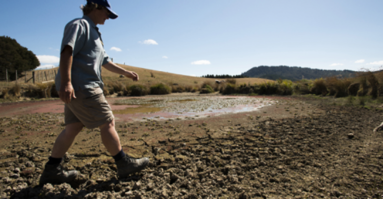
New economic research co-funded by the Deep South Challenge and Manaaki Whenua – Landcare Research, with the support of Motu Economic and Public Policy Research, will investigate the impact of climate change-driven drought on vulnerable communities.
What has happened in the past, and what might happen in the future, to local spending, income, wages or employment during droughts? What are the long-lasting effects? Where does labour go and does it return? What does drought do to agriculture and tourism profits, food production, land values, debt and communities?
Research co-lead Dr Lynn Riggs (Motu Economic and Public Policy Research) says, “My aim is to understand what drought does to people who are at ground-zero and then how the impacts reverberate out to other communities. I hope this will improve our ability to plan for and avoid the worst.”
New Zealand’s agricultural land is among the highest valued in the world, and our mild, moist climate is a large part of the reason why. A changing climate, including worse or more frequent droughts, poses a substantial risk to our land assets, and therefore makes our rural communities vulnerable. Dr Riggs continues, “Vulnerable communities will be most at risk when climate change comes to bear… Drought in particular is a really complex issue and has a massive web of inter-related impacts. My job in this project is to help figure out how rural businesses, local economies and farming communities will be economically and personally affected by climate-driven drought.”
In New Zealand, there is very little research about the implications of climate change for society using approaches that measure the historical relationship between weather conditions and economic and social outcomes. This project will begin to fill this critical research gap by analysing how drought frequency and intensity impact financial outcomes on farms, and, as a consequence, on rural communities. Using climate change projections from NIWA, the research will also simulate the future implications of climate-driven drought for farms and for communities.
Manaaki Whenua research co-lead, Dr Kendon Bell, says, “I’m excited to learn about the financial implications of drought and climate change for farmers and rural communities… The rural sector is really important to Aotearoa and no other group’s livelihood depends so heavily on the weather and climate. Rural communities may bear a large share of the burden of reducing emissions and our job is to try and understand, using real financial data, the size of the additional burden (or benefit) that climate change might impose.”
This research will support decision makers to understand which communities, regions and industries will be hardest hit by drought events, and how.
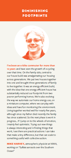
Spring has sprung and it’s time for renewal! We’d like to welcome Mike Harvey (NIWA) to our Challenge Leadership Team (CLT), as our Processes and Observations programme lead.
Mike has a PhD in environmental physics and has led atmospheric research programmes at NIWA for the last 14 years. He’s had a long-term interest in improving our understanding of important environmental processes, which among other things helps us understand the efficacy of some climate change mitigation actions.
Mike says, “Society recognises the challenge associated with ‘decarbonising’ economies. Global action has not been rapid, but in more recent times interest and ideas around mitigation are growing, along with a more integrated approach to mitigation and adaptation.”
Mike was involved in Phase 1 of the Challenge. “I’ve been involved in the Clouds and Aerosols project,” he says, “gathering new data to improve understanding of the interactions between aerosols and clouds over the Southern Ocean, where clean maritime conditions are very different to the better-observed Northern Hemisphere. I’m inspired by the way the Challenge is providing new opportunities and a platform for collaborators to advance this work. The team has been building a more integrated approach to measurement and modelling. We’ve also seen how the Challenge’s strong engagement programme helps focus the science on what can be delivered now and for the future.”
What has drawn Mike to want to contribute to the Challenge’s leadership? “This is a great opportunity to help shape the Phase 2 of Process and Observations studies,” he says. “I see this as contributing to the important next steps in Earth System Model improvement as well as to the broader Challenge objective, which is considering key climatic influences for New Zealand.”Mike also has a small but seriously inspiring cameo in the “Diminishing Footprints” series of our recent Challenge magazine, “Kia Urutau | Adapt”:
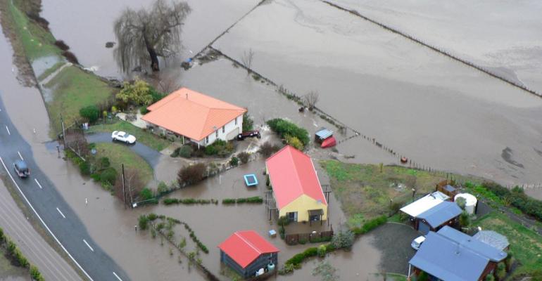
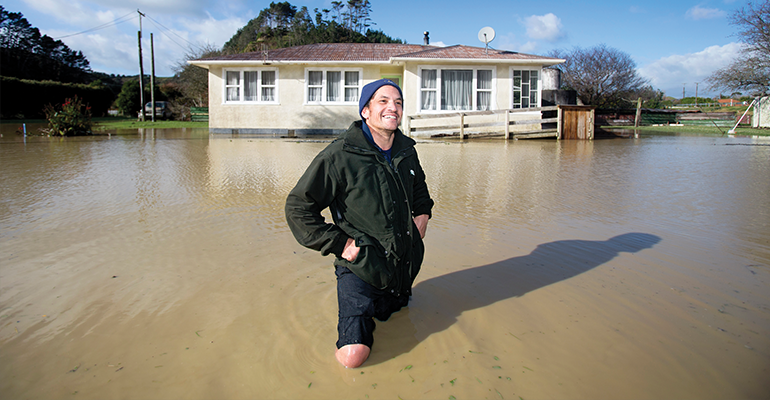
Two reports released today by NIWA and the Deep South National Science Challenge reveal new information about how many New Zealanders, how many buildings and how much infrastructure could be affected by extreme river and coastal flooding from storms and sea-level rise.
One report looks at what would happen when rivers are flooded by heavy rain and storms, while the other examines flooding exposure in coastal and harbour areas and how that might change with sea-level rise.
NIWA researcher Ryan Paulik says the New Zealand Fluvial (river) and Pluvial (rainfall) Flood Exposure report is a first cut at identifying the amount of exposure to flooding at a national scale based on available flood maps.
Their findings show that across the country almost 700,000 people and 411,516 buildings worth $135 billion are presently exposed to river flooding in the event of extreme weather events. With climate change, more extreme rainfall events are expected to occur – but weren’t covered in this report. Also exposed are 19,098 km of roads, 1574km of railways and 20 airports.
Urgent need for national flood risk maps
The information was put together using a range of flood maps and data published by local authorities, central government organisations, Crown Research Institutes and Land Information New Zealand. However, Mr Paulik says while the information used was the best publicly available, it varied in detail and age, which means the findings are general and should only be used as a first nationwide estimate.
Mr Paulik says the research has revealed an urgent need for national flood risk maps.
“National flood risk maps are essential because we need accurate and comprehensive information about the impact and costs of flooding today and under different climate change scenarios so everyone can plan and adapt.”
A range of technical recommendations have been made to central government about how the national maps could be produced.
Coastal flooding exposure under future sea level rise
The second report, Coastal Flooding Exposure Under Future Sea Level Rise, looks at extreme storm-tide flood levels (one-in-100 year flood events) combined with various sea levels up to 3 metres higher than they are today.
Mr Paulik and Dr Rob Bell modelled coastal floods that can occur when a storm surge coincides with a large high tide to cause extreme flood heights. This scenario must be planned for under the New Zealand Coastal Policy Statement.
The sea-level rise modelling builds on flood mapping work undertaken by the Parliamentary Commissioner for the Environment (PCE) in 2015. The PCE study used Mean High-Water Spring (the highest level that spring tides reach on average) as a baseline and did not take in account flooding during an extreme storm. Mr Paulik and Dr Bell have replaced this measure with a one-in-100 year extreme sea level event such as an ex-tropical storm or major storm. They then assessed the risk exposure for 10 cm increments of sea-level rise up to 3 metres.
Over 70,000 New Zealanders currently at risk
This second report shows 72,000 New Zealanders currently exposed to present-day extreme coastal flooding, along with about 50,000 buildings worth $12.5 billion. The risk exposure increases markedly with sea-level rise, particularly during the first metre of rise, which means long-term planning to address the risk is urgent.
There is near certainty that the sea will rise 20-30 cm by 2040. By the end of the century, depending on whether global greenhouse gas emissions are reduced, it could rise by between 0.5 to 1.1 m, which could add an additional 116,000 people exposed to extreme coastal storm flooding.
Dr Bell said it was important for councils addressing coastal adaptation to prioritise the areas most at risk but also to undertake regional 100-year risk assessments to inform where land-use planning restrictions are put in place to limit future intensification – even if coastal flooding was some years away.
Two reports released today by NIWA and the Deep South National Science Challenge reveal new information about how many New Zealanders, how many buildings and how much infrastructure could be affected by extreme river and coastal flooding from storms and sea-level rise.
One report looks at what would happen when rivers are flooded by heavy rain and storms, while the other examines flooding exposure in coastal and harbour areas and how that might change with sea-level rise.
Their findings show that across the country almost 700,000 people and 411,516 buildings worth $135 billion are presently exposed to river flooding in the event of extreme weather events. With climate change, more extreme rainfall events are expected to occur – but weren’t covered in this report. Also exposed are 19,098 km of roads, 1574km of railways and 20 airports.
Urgent need for national flood risk maps
The information was put together using a range of flood maps and data published by local authorities, central government organisations, Crown Research Institutes and Land Information New Zealand. However, Mr Paulik says while the information used was the best publicly available, it varied in detail and age, which means the findings are general and should only be used as a first nationwide estimate.
Mr Paulik says the research has revealed an urgent need for national flood risk maps.
“National flood risk maps are essential because we need accurate and comprehensive information about the impact and costs of flooding today and under different climate change scenarios so everyone can plan and adapt.”
A range of technical recommendations have been made to central government about how the national maps could be produced.
Coastal flooding exposure under future sea level rise
The second report, Coastal Flooding Exposure Under Future Sea Level Rise, looks at extreme storm-tide flood levels (one-in-100 year flood events) combined with various sea levels up to 3 metres higher than they are today.
Mr Paulik and Dr Rob Bell modelled coastal floods that can occur when a storm surge coincides with a large high tide to cause extreme flood heights. This scenario must be planned for under the New Zealand Coastal Policy Statement.
The sea-level rise modelling builds on flood mapping work undertaken by the Parliamentary Commissioner for the Environment (PCE) in 2015. The PCE study used Mean High-Water Spring (the highest level that spring tides reach on average) as a baseline and did not take in account flooding during an extreme storm. Mr Paulik and Dr Bell have replaced this measure with a one-in-100 year extreme sea level event such as an ex-tropical storm or major storm. They then assessed the risk exposure for 10 cm increments of sea-level rise up to 3 metres.
Over 70,000 New Zealanders currently at risk
This second report shows 72,000 New Zealanders currently exposed to present-day extreme coastal flooding, along with about 50,000 buildings worth $12.5 billion. The risk exposure increases markedly with sea-level rise, particularly during the first metre of rise, which means long-term planning to address the risk is urgent.
There is near certainty that the sea will rise 20-30 cm by 2040. By the end of the century, depending on whether global greenhouse gas emissions are reduced, it could rise by between 0.5 to 1.1 m, which could add an additional 116,000 people exposed to extreme coastal storm flooding.
Dr Bell said it was important for councils addressing coastal adaptation to prioritise the areas most at risk but also to undertake regional 100-year risk assessments to inform where land-use planning restrictions are put in place to limit future intensification – even if coastal flooding was some years away.
“We need to put the brakes on development in coastal areas even if areas may not be impacted for a few decades – given the sea level will continue rising,” he said.
We need to put the brakes on development in coastal areas even if areas may not be impacted for a few decades – given the sea level will continue rising.
Councils across New Zealand are declaring climate emergencies. But what climate information are they using to make their decisions and inform their communities? In this seminar, we’ll hear from Ryan Paulik and Rob Bell (NIWA), whose ground-breaking research investigates how flooding will get worse under climate change – both at the coast and inland, alongside our rivers.
Recent cyclones have shown us how vulnerable we all are to extreme weather – whether we’re living on the coast or inland in a flood-plain.
But what happens when you add 10cm or 30cm or 1m of sea level rise to the picture? Or when big rain events hit rural areas, or towns, or cities, that may not have been hit so badly before?
The research builds on and improves national flood mapping carried out by the Parliamentary Commissioner for the Environment in 2015, and provides a comprehensive picture of the impact of coastal and inland flooding on our national infrastructure, including our buildings, roads, railways, airports, electricity transmission lines, water infrastructure and farms.
Due for release in September, the research is presented in two reports. The first describes what infrastructure will be exposed for every 10cm of sea level rise (up to 3m), including when coupled with one-in-100-year storms. For example, 30 centimeters of sea level rise (foreseeable in the next 30 years) would expose $18.49 billion worth of buildings around New Zealand to flooding. Further, 2,000 kms of roads, 112 kms of railway tracks, 4,000 kms of water pipelines, 1,600 sq kms of agricultural land, 14 domestic / international airports would also be exposed. Slide up to 1m of sea level rise, and the dollar value of exposure increases to $39 billion.
The second report maps inland flood risk against infrastructure, and finds, for example, that a staggering $135 billion worth of buildings are potentially exposed. Add to this almost 19,000 kms of roads, 1,500 km of railway tracks, 21,173km of water pipelines, 3,397 km of national grid transmission lines and 20 airports, and you begin to get a sense of the challenges ahead of us. But if we can accurately predict the areas of highest risk, we can better adapt, minimising harm to New Zealand’s population and economy.
Come and gain an overview of these reports in advance of release, understand the limitations of the data and the team’s recommendations for further research.
This research will support further development of RiskScape (open access software developed by NIWA and GNS Science), which can directly help those people whose job it is to manage flood risk.
Physical hubs:
NIWA Wellington: Conference Room*
NIWA Christchurch: TerraNova Room
NIWA Lauder: Computer Room
University of Canterbury: Meremere 411
School of Law Building: University of Otago:
Conference Room (Room 314): Physics Department
*Our presenters will be speaking from this hub.
Please note, all visitors to NIWA must sign in on arrival.
We encourage you to set up your own hub and bring friends and colleagues together to participate in the seminar. Please let us know if you do set up your own hub.
In the aftermath of the MV Rena grounding in the Bay of Plenty, complaints were taken to the Waitangi Tribunal and the Environment Court about the way local and central government handled the disaster.
Once the Rena had stranded on Otaiti (Astrolabe Reef), the Crown acted quickly – making decisions about if, how and when to remove the wreck. In its haste, it overlooked its Treaty of Waitangi obligations to actively protect and partner with mana whenua. The Tribunal found that the Crown had breached the Treaty, and in particular let iwi down by not facilitating consultation – putting at risk “their ability to engage meaningfully in the resource consent [RMA] process.”
New research, led by Catherine Iorns (Victoria University of Wellington) and funded by the Deep South Challenge: Changing with our Climate, explores the Crown’s potential liability under the Treaty of Waitangi for decisions about how we might adapt to climate change. The research suggests that the MV Rena decision, along with other key case studies, provides guidance for the Crown about its Treaty duties in relation to climate adaptation decision-making.
It finds, for example, that the Crown should not create policies and laws that undermine the ability of iwi to protect the whenua (land). In the case of climate adaptation, this is difficult, because while this duty is on the Crown, many – if not most – climate adaptation decisions are currently being made by local and regional councils under the Resource Management Act (RMA). Further, as with the MV Rena, the Treaty obligations of active protection and partnership, especially the facilitation of consultation, will apply, even in commercial negotiations with an overlay of confidentiality and urgency.
The research explores five case studies (at Matatā, the Hawkes Bay, Mōkau River, Waitara and in Whaingaroa/Raglan), and concludes that central government should be playing more of a role in guiding local government decision-making processes, to ensure the Treaty principles of partnership, governance, reciprocity, active protection, good faith, consultation and development are followed in climate adaptation decision-making processses.
Active protection suggests the maintenance of Māori relationships with the coast. Iorns’ research finds that central government funding (as the Treaty partner) should therefore first be directed towards maintaining these relationships.
Where managed retreat needs to be discussed, especially from ancestral lands, tangata whenua will likely need to involved as equal partners in decision-making – a relationship involving more than “significant consultation” by the Crown. If there is to be managed retreat from the coast, relationships with traditional territories would still need to be maintained even in the absence of ownership. For that, access to coastal territories would be required.
The climate adaptation measures needed both now and in the future will likely have significant implications for the protection of iwi taonga/assets under Article 2 of the Treaty of Waitangi. Iorns finds that central and local government need to keep in mind the wider picture of upholding Treaty principles, rather than the minimum conditions in the RMA, in order to avoid modern Treaty breaches in relation to these assets. This necessarily implies that more attention must be paid to factual and legal issues in this area, to ensure that the Treaty of Waitangi is upheld, as we change in time for our changing climate. Please find the full report and more information about Catherine Iorns’ research here.
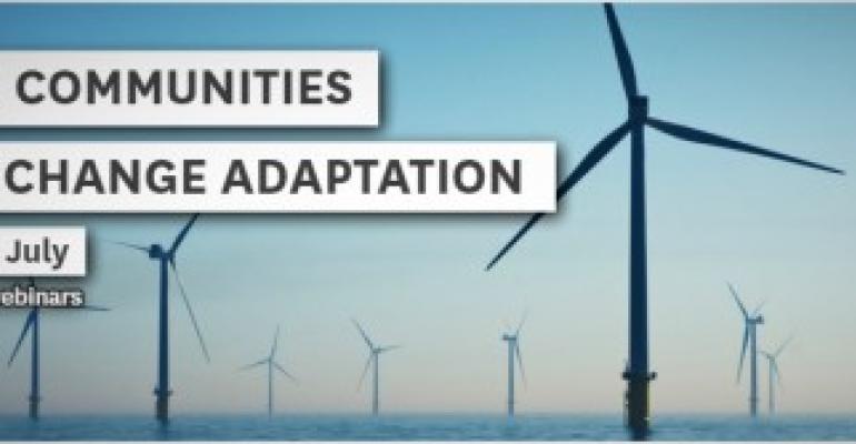
This three-part webinar series draws from the Climate-Adaptive Communities research project of the Deep South Challenge.
Climate change is already impacting councils and communities Around New Zealand, people are starting to grapple with the challenges of increasing sea levels, groundwater levels, and more severe flood events. As well as impacting on infrastructure, these will have significant societal implications both in the short term and long term. In the near future, many councils will need to start engaging with exposed communities about what this might mean.
This three-part webinar series draws from the Climate-Adaptive Communities research project of the Deep South Challenge. The research included a survey of councils and case studies of several local authority areas that are exposed to climate change impacts. We looked at how councils are engaging with their communities, how communities (especially those more susceptible to harm) may be affected, and what adaptation initiatives are already being undertaken by iwi and communities.
Director of the Centre for Sustainability Dr Janet Stephenson, along with Grace Hall, Sophie Bond, and Gradon Diprose will be your presenters on these essential topics.
Presented in partnership with the Deep South Challenge, these webinars are offered free of charge.
Furthermore, as part of this work we have produced 2 short videos, a council briefing document, and a cartoon, to help in conveying key messages to a broad audience of councils, communities, and government. These are available to be part of the package of webinars.
To register for this series, please email [email protected]. Click the links below to find out more about each webinar.
To minimise suffering as we adapt to climate change, and to adapt successfully, local authorities need new ways to engage with communities.
Every regional council in the country, and over a quarter of our local councils, face extreme exposure to climate hazards like coastal erosion, flooding and rising groundwater levels.
Over the coming years, communities will have to make near-impossible decisions – from how to pay for expensive coastal defence systems to when we should think about picking up our survey pegs and walking backwards from the coastline.
Communities will face increasing physical, social, financial and emotional challenges, and councils are already looking to central government to provide a cohesive framework for the planning and funding of adaptation. But to minimise suffering as we adapt – and to adapt successfully – local authorities also need new ways to engage with communities.
Recently concluded research by a team led by Janet Stephenson (University of Otago), draws on stories and insights from community members, iwi members and council staff. Their project findings suggest that council engagement with communities about climate impacts requires more than ‘business as usual’ engagement processes, because:
Adaptive decisions will need to be made at many points in time, probably over decades
These decisions often have to be made without a full understanding of what the future holds
Multiple individual decisions could result in inequitable outcomes, unless council has an overview of implications for the entire community
The community members most severely affected may well be those who are least empowered and least accustomed to ‘having a say’ in council decisions
It takes time to build the trust and capacity to be involved in decisions that have such far-reaching implications.
This research enriches the existing MfE Coastal Hazards and Climate Change Guidance by providing advice for councils and community groups on how and when to engage on climate change. The guidance recommends a Dynamic Adaptive Pathways Planning (DAPP) approach to engagement, by which critical decision points for adaptation investments are pre-defined.
This framework supports local government staff (from adaptation advisors to community development teams to community groups themselves) to build community readiness to engage at these critical decision points. It also provides tools for those who want to organise together to build resilience:
A survey and report of councils, which explores why councils find it so challenging to meaningfully engage (background report for researchers or those seeking more in-depth information)
Policy guidance (including engagement framework) for local government adaptation and community development staff
Conversation starters for community engagement staff:
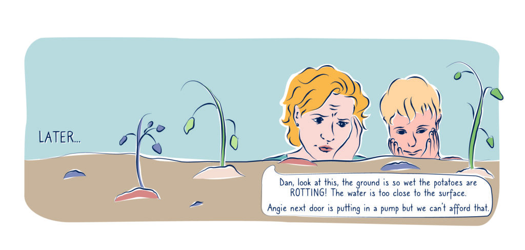
Short graphic story introducing two young friends who live in a community affected by climate change. The pair reveal how devastating climate change can be and begin to understand the strength communities have when they work together on solutions
Two short videos based in South Dunedin, one exploring a neighbourhood’s response to the 2015 floods and subsequent events; the other exploring Dunedin City Council’s response and move towards proactively planning for climate hazards.
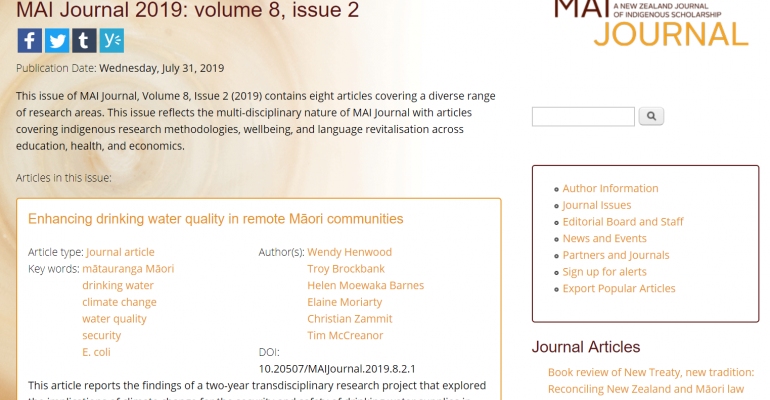
The iwi of Te Hiku o Te Ika are concerned about the impact of climate change on household drinking water. Results from this research, grounded in three rural Northland communities, have now been published in MAI: A New Zealand Journal of Indigenous Scholarship.
Isolation in the Far North means that roof-fed tank systems are the predominant source of drinking water for these communities. Understanding how climate change will impact water supplies has helped these communities prepare for the future, prioritise actions and mitigate detrimental effects.
The large research team led by Wendy Henwood of Te Rarawa included mana whenua community researchers at each location, iwi members, the Whāriki Research Group (Massey University), ESR and NIWA. Community researchers recorded daily rainfall and temperature data, surveyed household drinking water infrastructure and monitored water quality by taking household samples. NIWA and ESR team members used the data to model climate change scenarios and E.Coli contaminations, and kaumatua contributed mana whenua views.
The project highlighted the potential impacts of the general “hotter, drier” climate predictions for Te Hiku on the security and safety of drinking water supplies. Overall lower rainfall suggested the need for greater tank storage volumes. However, increased ambient temperatures are likely to converge with longer storage periods, to increase the pathogen count in these drinking water stores.
Throughout the research, practical strategies and innovations were shared about how to minimise water contamination, including about where to place septic tanks, how to protect water sources, the need for possum and rat trapping programmes, the importance of regular maintenance and upgrades, and de-sludging tanks. First flush diverters, UV treatment, and filters were described as solutions to improve water quality in some situations. Communities were acutely aware of the need to store more water and this, as well as the need for infrastructure upgrades at a number of households, all involve cost.
While the research focused on household drinking water, the issue was not viewed in isolation. Water is part of the environment, the people, and a whakapapa to Ranginui and Papatūānuku. Fresh and salt-water are the basis for land-use decisions (farming, gardens, orchards, fishing). Lifestyles revolved and revolve around its catchment. By creating specific, located, Māori knowledge about water sustainability, as a key dimension of community viability, this project has kick-started preparations in Te Hiku for the effects of climate change on people, ecosystems, lands and economy.
Quotes from kaumātua are woven throughout the final research report (see below) and are a moving testimony to the wealth of mātauranga Māori held in Te Hiku about our changing climate.
Local kaumatua have always observed and lived by the weather, practised kaitiakitanga, and acknowledged water’s vital interconnectedness with the environment. These elders are not fazed by the impact of climate change. Their resilience stems from a lifetime of working with the weather, growing up valuing water, and having the necessary knowledge and life skills to adapt to changing situations and realities. Theirs is an attitude that broader New Zealand could learn much from.