Author: Alex

Sea level rise and the law: Who is liable?

A full suite of research papers has just been released looking at the broad question of liability for damage caused by sea level rise. The reports are the work of legal researcher Catherine Iorns (Victoria University of Wellington), whose Deep South Challenge project “Sea level rise, housing and insurance: Liability and compensation” arose from a 2017 “Deep South Dialogue” between researchers, the insurance sector and local and central government.

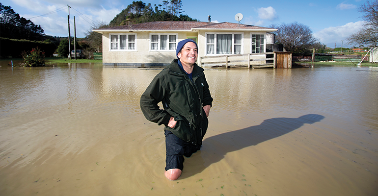
Iorns’ research examines the range of possible options available to local, regional and national government to adapt to climate change, and the question of who might be responsible for costs. Residential housing is an important focus, in light of the likely uninsurability of some coastal properties due to the increasing coastal hazards faced from sea-level rise and climate change.

A brief summary of the reports, all available in full here, follows. 

Case Studies on Insurance and Compensation after Natural Disasters

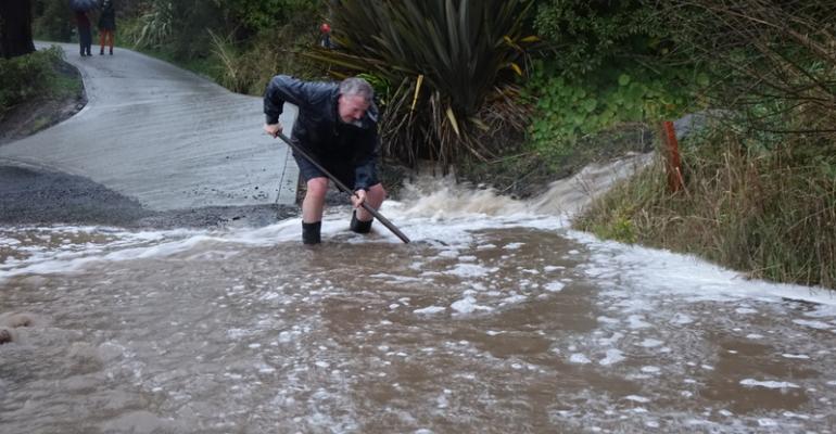
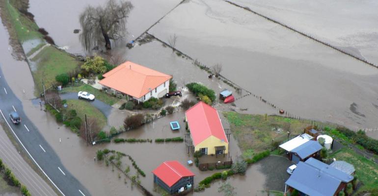
This paper considers some examples of where financial risks to property have fallen both in New Zealand and overseas as a result of some natural disasters, particularly flooding. Pre-existing schemes are important for discussing possible future policy responses as they are and how they could be adapted for new and different natural hazards. This paper examines ways that risk, damage, cost and liability currently fall under different schemes. Private insurance, state supported insurance, the Public Works Act 1981 and council liability could be used to share losses of value and utility of land. Each of them has weaknesses.

However, they could be used, adapted and/or combined to create a framework to deal with loss of value and utility of land due to sea-level rise. If any government subsidy scheme were to be adopted, it would need to avoid the problems of previous compensation schemes here and overseas, and be carefully designed to enable people to assess and manage the risks to their homes and communities fairly. What is fair won’t be determined by analysis of what is currently legal, but needs to be the subject of a wider discussion.

Adaptation to Sea-Level Rise: Local Government Liability Issues

This report addresses the legal framework surrounding local government responsibilities to adapt to the coastal hazards associated with the sea-level rise from climate change. Significant work has already been done in this area, including a legal opinion from Simpson Grierson for LGNZ, and other academic work on individual elements of the legal framework. This paper tries to pull these together and summarise aspects that are relevant for the potential future actions necessary, including:

  • general considerations in climate adaptation measures, including relevant values, the precautionary principle, and direction and guidance on coastal hazards from central government
  • new developments – the prevention of them or placing conditions on development
  • coastal protection works in hazardous coastal areas
  • managed retreat, particularly the difficulties within the current legal rules and ways that it may be able to be undertaken
  • existing residential use rights and how these might be modified under a Regional Plan
  • the use of acquisition and information instruments
  • liability in negligence for council consenting decisions.

Sea-level rise and local government: Policy gaps and opportunities

This paper identifies some barriers, gaps and opportunities in the legal and policy options available to local government when managing the effects of sea-level rise due to climate change, and outlines the challenges facing local government in adapting to sea-level rise and climate change.  Work undertaken to inform the paper includes research, engagement, and policy analysis over a two-year period, with findings tested in a survey of local authorities with coastal interface (territorial authorities) or whose authority included coastal marine areas (regional and unitary councils).

The most prominent message from this work is the desire for more commitment and involvement from central government. Territorial authorities in particular are seeking a stronger lead, such as legislative reform, clearer and more directive policy, clarification of responsibilities, guidance on the use of particular adaptation tools that currently exist, and a national environmental standard on coastal hazard management. Such direction is seen as critical not only to achieve a nationally consistent approach but also simply to achieve the adoption of appropriate climate adaptation measures.

The extent of EQC liability for damage from sea-level rise

This paper considers the extent to which damage from storm surges, flooding and landslips associated with sea-level rise is covered by insurance against natural disaster provided under the Earthquake Commission Act 1993 (the Act) administered by the Earthquake Commission (EQC).

Treaty of Waitangi duties relevant to adaptation to coastal hazards from sea-level rise

Māori communities are likely to be severely affected by sea level rise, with many rural Maori communities situated along the coast. Where communities have limited economic power and access to finance, and little or no insurance cover, effective policy options for uninsurable Māori housing are critical. This paper was released to the public in the second half of 2019.

DSC Seminar Series | Flood management in NZ: is it fair?

New Deep South Challenge research on flood management funding shows a need for a more coordinated approach between regional councils, particularly with more storms and sea-level rise on the horizon. This seminar with Patrick Walsh (Manaaki Whenua Landcare Research) will explore council-run “flood mitigation schemes” – both their effectiveness in reducing flood damage and whether they’re a fair way to manage flood risk.

Flooding is the most economically damaging natural hazard in New Zealand, and costs will only increase as climate change continues to cause more flooding. Local and regional councils are responsible for reducing the impact of flooding, by building stopbanks, for example, or by stabilising rivers through planting. Councils are also required to consider flooding when making planning decisions about new property developments.

Flood mitigation work is expensive and most councils top up their funds by encouraging property owners in flood-prone areas to institute a flood mitigation scheme. Neighbourhoods can also campaign to institute a flood scheme in their area. These schemes use targeted rates to fund additional flood management.

Yet council-run flood mitigation schemes do not benefit everyone equally. Property owners in less affluent communities are less likely to join voluntary funding schemes. These communities are also less likely to have the leverage or influence needed to lobby their councils about flood risks or flood protection.  

With sea-level rise increasing both the extent of land threatened by flood, as well as increasing the damage in existing flood risk areas, these concerns will only increase over time. Without careful management, inequality could increase alongside increased flooding and sea-level rise.

About our presenter

Patrick Walsh is a senior economist with Manaaki Whenua Landcare Research (MWLR). Patrick leads MWLR’s Empirical Economics cluste, a team of environmental and agricultural economists working on applied economic research. Patrick specialises in applied econometrics and cost-benefit analysis and researches a range of environmental and natural resource economics issues, including water quality, invasive species, conservation, afforestation and natural hazards. Patrick previously worked at the US Environmental Protection Agency (EPA) in the National Center for Environmental Economics. 

Physical hubs: 

  • Manaaki Whenua Auckland: Totoo Mauri Room*
  • NIWA Wellington: VC Allen Board Room
  • NIWA Christchurch: VC TerraNova Room
  • NIWA Lauder: VC Computer Room
  • University of Auckland: Room 301-411
  • University of Canterbury: Meremere 411, School of Law Building
  • University of Otago: VC Room 312, Physics Department

*Our presenter will be speaking from this hub.

Please note, all visitors to NIWA must sign in on arrival.

We encourage you to set up your own hub and bring colleagues together to participate in the seminar. Please let us know if you do set up your own hub and would like to test your VC facility prior to the seminar.

Climate adaptation within New Zealand’s transport system

Climate change threatens our transport system. We need clear rules and signals.

Love cars and hate trains? Love trains and hate planes? Love your bike but rely on trucks, trains, ships or planes to get the goods in and out of our communities? Either way, transport infrastructure underpins the social and economic fabric of modern life. And climate change is set to impact this infrastructure in multiple ways.

This Motu ‘Note’ is the result of a 2018 Deep South Dialogue investigating knowledge gaps around climate change and our transport system. The Dialogue brought together a range of stakeholders across central and local government agencies, as well from industries that are heavily reliant on transport, to tease out critical issues for the transport sector as it begins to look towards adaptation options.

We know that climate change will cause infrastructure damage and disruption to transport networks.  But adaptation across the transport network is not simple. Transport assets are long-lived and the costs involved are significant. Uncertainty around the timing and location of climate impacts makes planning challenging. The varying ‘criticality’ of each component of the transport system is not uniformly measured, making it tricky to allocate resource for adaptation efficiently. Coordination across the different institutions that make up and rely on the transport system is no easy task. Nevertheless, there are opportunities for adaptation in the normal cycle of infrastructure build and renewal.

The Note sets out current thinking around the importance of taking a systems approach to adaptation in the transport sector. Inter-dependency between transport and other sectors means that delaying adaptation decisions also delays investments and decisions made in other parts of the economy, and may lead to poor decisions about where to build new infrastructure.

The Dialogue, and the subsequent research gaps identified, are helping the Deep South Challenge work with key stakeholders across the transport sector on their adaptation journey.  It is something that is now front of mind for all key agencies that are responsible for the infrastructure we rely on and the Deep South Challenge can provide long-term climate information to help these agencies plan and adapt to ensure we can all keep moving in the future.

Read the report here:

DSC Seminar | How climate models deal with ice around Antarctica

We make decisions based on what we think will happen in the future, and where climate is concerned, these decisions often involve a cost. There’s a balance between the costs involved in preparing for future change now, and the cost of being unprepared for change when it arrives. To assess this balance and prepare effectively, we need to understand how reliable the evidence from climate models is.

For all climate models, finite computing resources mean that some physical processes have to be heavily simplified or excluded from the calculations. It’s important that we understand the effect this has on our projections for future climate so that we know what to expect, and whether or not it might be slightly different to what the models tell us.

In New Zealand, our climate is strongly influenced by things that happen in the Southern Ocean. One example of this is the increased rate at which ice is melting around Antarctica, which is generally not captured in climate models. Fresh melt water entering a salty ocean sits at the surface, preventing deeper, warmer water from cooling through contact with the atmosphere. This impacts ocean circulation, which is how most heat is transported around the planet. The melt also cools the ocean surface and drives sea ice formation. White, reflective sea ice, covering an otherwise dark ocean, changes the amount of solar energy received by the ocean (rather than reflected back into space), and so impacts the rate at which the Earth warms up. There are good reasons for not including the increasing melt rate, which Shona will explain in this seminar. Nevertheless, we are interested in the effect of the omission on climate projections. Understanding this will help us to better understand what changes to expect in future. Shona will explain why we’re concerned that the ice melt is speeding up, and present some of the ways in which ignoring it affects what we predict for future climate.

As computing resources expand, models are developed so that more processes are included, making climate projections more accurate. Until recently, most development has taken place in the northern hemisphere, and has focused on areas particularly important to future climate there. Years of making and analysing observations in Antarctica and the Southern Ocean have made New Zealand scientists world leaders in the region that is important to our climate here. We are using this expertise to improve the accuracy of our climate projections by including processes that we think make a difference to southern hemisphere climate. An example is the way that new sea ice forms around Antarctica every year. In most climate models, it forms more quickly and thinly than in reality, covering the ocean surface too soon, increasing its reflectivity and preventing the ocean from cooling. We are working to improve this by including a more realistic treatment of sea ice in the New Zealand Earth System Model.

About our presenter

Shona Mackie has a Physics MSci from Bristol University, an MSc in Glaciology from Aberystywyth University, and completed her PhD at Edinburgh University working with the UK Met Office on improving how we interpret satellite data for weather forecasts. She then moved into renewable energy consultancy, providing wind energy forecasts for utility companies and financial institutions. The eruption of Eyjafjallojokull volcano in 2010, and the chaos it brought to European air travel, brought Shona back to research to improve the way we detect, monitor and forecast volcanic ash in the air. Noting that climate change is probably the biggest threat to our society over the medium-to-long term, and how much we urgently need to understand in order to prepare for it, Shona saw an opportunity to contribute to the international research effort (and renew her interest in icy places). Two years ago, she moved with her husband to New Zealand to work at Otago University on sea ice and climate modelling. 

Physical hubs: 

  • University of Otago: VC Room 312, Physics Department*
  • NIWA Wellington: VC Conference Room
  • NIWA Christchurch: VC TerraNova Room
  • NIWA Lauder: VC Computer Room
  • University of Canterbury: Meremere 411, School of Law Building

*Our presenter will be speaking from this hub.

Please note, all visitors to NIWA must sign in on arrival.

We encourage you to set up your own hub and bring colleagues together to participate in the seminar. Please let us know if you do set up your own hub and would like to test your VC facility prior to the seminar.

Email: [email protected]

“Domains” research funding round: Now open!

Be a part of the Deep South Challenge research rōpū, and help enable Aotearoa New Zealand to prepare for our changing climate.

We are now seeking funding proposals for our Domains Research. We’re looking to fund research that will enable climate-sensitive sectors – hapū and iwi, business, and local and central government – to adapt to climate change.

Funding proposals are due 8 November 2019 with an expected start date of 1 April 2020.

We invite proposals to:

  • the Māori domain
  • the three domains of Communities, Infrastructure and the National Economy.
MĀORI DOMAIN

We are looking for research projects that will contribute substantive and transformative outcomes for Māori and for wider Aotearoa New Zealand. These must fit within the Challenge’s mission, to enable New Zealanders to anticipate adapt, manage risk, and thrive in a changing climate.

Please find all the documentation you need to submit a research proposal at this section of our website.

COMMUNITIES, INFRASTRUCTURE, NATIONAL ECONOMY DOMAINS

We are calling for research that focuses on: making and improving projections of New Zealand’s future climate; the impacts and implications of climate change for Aotearoa New Zealand; and enabling adaptation to climate change.

Research proposals should address the research themes of multiple impacts, effective adaptation, water and land and the economy.

Please find all the documentation you need to submit a research proposal at this section of our website.
 

We look forward with anticipation to your innovative, high-impact and end user-relevant research proposals.

‘Ground zero’: How will climate-driven drought impact rural communities?

New economic research co-funded by the Deep South Challenge and Manaaki Whenua – Landcare Research, with the support of Motu Economic and Public Policy Research, will investigate the impact of climate change-driven drought on vulnerable communities.

What has happened in the past, and what might happen in the future, to local spending, income, wages or employment during droughts? What are the long-lasting effects? Where does labour go and does it return? What does drought do to agriculture and tourism profits, food production, land values, debt and communities?

Research co-lead Dr Lynn Riggs (Motu Economic and Public Policy Research) says, “My aim is to understand what drought does to people who are at ground-zero and then how the impacts reverberate out to other communities. I hope this will improve our ability to plan for and avoid the worst.”

New Zealand’s agricultural land is among the highest valued in the world, and our mild, moist climate is a large part of the reason why. A changing climate, including worse or more frequent droughts, poses a substantial risk to our land assets, and therefore makes our rural communities vulnerable. Dr Riggs continues, “Vulnerable communities will be most at risk when climate change comes to bear… Drought in particular is a really complex issue and has a massive web of inter-related impacts. My job in this project is to help figure out how rural businesses, local economies and farming communities will be economically and personally affected by climate-driven drought.”

In New Zealand, there is very little research about the implications of climate change for society using approaches that measure the historical relationship between weather conditions and economic and social outcomes. This project will begin to fill this critical research gap by analysing how drought frequency and intensity impact financial outcomes on farms, and, as a consequence, on rural communities. Using climate change projections from NIWA, the research will also simulate the future implications of climate-driven drought for farms and for communities.

Manaaki Whenua research co-lead, Dr Kendon Bell, says, “I’m excited to learn about the financial implications of drought and climate change for farmers and rural communities… The rural sector is really important to Aotearoa and no other group’s livelihood depends so heavily on the weather and climate. Rural communities may bear a large share of the burden of reducing emissions and our job is to try and understand, using real financial data, the size of the additional burden (or benefit) that climate change might impose.”

This research will support decision makers to understand which communities, regions and industries will be hardest hit by drought events, and how.

Welcome to Mike Harvey, new Processes & Observations programme lead

Spring has sprung and it’s time for renewal! We’d like to welcome Mike Harvey (NIWA) to our Challenge Leadership Team (CLT), as our Processes and Observations programme lead.

Mike has a PhD in environmental physics and has led atmospheric research programmes at NIWA for the last 14 years. He’s had a long-term interest in improving our understanding of important environmental processes, which among other things helps us understand the efficacy of some climate change mitigation actions.

Mike says, “Society recognises the challenge associated with ‘decarbonising’ economies. Global action has not been rapid, but in more recent times interest and ideas around mitigation are growing, along with a more integrated approach to mitigation and adaptation.”

Mike was involved in Phase 1 of the Challenge. “I’ve been involved in the Clouds and Aerosols project,” he says, “gathering new data to improve understanding of the interactions between aerosols and clouds over the Southern Ocean, where clean maritime conditions are very different to the better-observed Northern Hemisphere. I’m inspired by the way the Challenge is providing new opportunities and a platform for collaborators to advance this work. The team has been building a more integrated approach to measurement and modelling. We’ve also seen how the Challenge’s strong engagement programme helps focus the science on what can be delivered now and for the future.”

What has drawn Mike to want to contribute to the Challenge’s leadership? “This is a great opportunity to help shape the Phase 2 of Process and Observations studies,” he says. “I see this as contributing to the important next steps in Earth System Model improvement as well as to the broader Challenge objective, which is considering key climatic influences for New Zealand.”Mike also has a small but seriously inspiring cameo in the “Diminishing Footprints” series of our recent Challenge magazine, “Kia Urutau | Adapt”:

New reports highlight flood risk under climate change

Two reports released today by NIWA and the Deep South National Science Challenge reveal new information about how many New Zealanders, how many buildings and how much infrastructure could be affected by extreme river and coastal flooding from storms and sea-level rise.

One report looks at what would happen when rivers are flooded by heavy rain and storms, while the other examines flooding exposure in coastal and harbour areas and how that might change with sea-level rise.

NIWA researcher Ryan Paulik says the New Zealand Fluvial (river) and Pluvial (rainfall) Flood Exposure report is a first cut at identifying the amount of exposure to flooding at a national scale based on available flood maps.

Their findings show that across the country almost 700,000 people and 411,516 buildings worth $135 billion are presently exposed to river flooding in the event of extreme weather events. With climate change, more extreme rainfall events are expected to occur – but weren’t covered in this report.  Also exposed are 19,098 km of roads, 1574km of railways and 20 airports.

Urgent need for national flood risk maps

The information was put together using a range of flood maps and data published by local authorities, central government organisations, Crown Research Institutes and Land Information New Zealand. However, Mr Paulik says while the information used was the best publicly available, it varied in detail and age, which means the findings are general and should only be used as a first nationwide estimate.

Mr Paulik says the research has revealed an urgent need for national flood risk maps.

“National flood risk maps are essential because we need accurate and comprehensive information about the impact and costs of flooding today and under different climate change scenarios so everyone can plan and adapt.”

A range of technical recommendations have been made to central government about how the national maps could be produced.

Coastal flooding exposure under future sea level rise

The second report, Coastal Flooding Exposure Under Future Sea Level Rise, looks at extreme storm-tide flood levels (one-in-100 year flood events) combined with various sea levels up to 3 metres higher than they are today.

Mr Paulik and Dr Rob Bell modelled coastal floods that can occur when a storm surge coincides with a large high tide to cause extreme flood heights. This scenario must be planned for under the New Zealand Coastal Policy Statement.

The sea-level rise modelling builds on flood mapping work undertaken by the Parliamentary Commissioner for the Environment (PCE) in 2015. The PCE study used Mean High-Water Spring (the highest level that spring tides reach on average) as a baseline and did not take in account flooding during an extreme storm. Mr Paulik and Dr Bell have replaced this measure with a one-in-100 year extreme sea level event such as an ex-tropical storm or major storm. They then assessed the risk exposure for 10 cm increments of sea-level rise up to 3 metres.

Over 70,000 New Zealanders currently at risk

This second report shows 72,000 New Zealanders currently exposed to present-day extreme coastal flooding, along with about 50,000 buildings worth $12.5 billion. The risk exposure increases markedly with sea-level rise, particularly during the first metre of rise, which means long-term planning to address the risk is urgent.

There is near certainty that the sea will rise 20-30 cm by 2040. By the end of the century, depending on whether global greenhouse gas emissions are reduced, it could rise by between 0.5 to 1.1 m, which could add an additional 116,000 people exposed to extreme coastal storm flooding.

Dr Bell said it was important for councils addressing coastal adaptation to prioritise the areas most at risk but also to undertake regional 100-year risk assessments to inform where land-use planning restrictions are put in place to limit future intensification – even if coastal flooding was some years away.

“We need to put the brakes on development in coastal areas even if areas may not be impacted for a few decades – given sea level will continue rising,” he said. Read the reports at the project page here: https://www.deepsouthchallenge.co.nz/projects/national-flood-risks-climate-change

Sea level rise and river flooding: flood risk under climate change

A man standing outside his house in knee-high water

Two reports released today by NIWA and the Deep South National Science Challenge reveal new information about how many New Zealanders, how many buildings and how much infrastructure could be affected by extreme river and coastal flooding from storms and sea-level rise.

One report looks at what would happen when rivers are flooded by heavy rain and storms, while the other examines flooding exposure in coastal and harbour areas and how that might change with sea-level rise.

NIWA researcher Ryan Paulik says the New Zealand Fluvial (river) and Pluvial (rainfall) Flood Exposure report is a first cut at identifying the amount of exposure to flooding at a national scale based on available flood maps.

Their findings show that across the country almost 700,000 people and 411,516 buildings worth $135 billion are presently exposed to river flooding in the event of extreme weather events. With climate change, more extreme rainfall events are expected to occur – but weren’t covered in this report.  Also exposed are 19,098 km of roads, 1574km of railways and 20 airports.

Urgent need for national flood risk maps

The information was put together using a range of flood maps and data published by local authorities, central government organisations, Crown Research Institutes and Land Information New Zealand. However, Mr Paulik says while the information used was the best publicly available, it varied in detail and age, which means the findings are general and should only be used as a first nationwide estimate.

Mr Paulik says the research has revealed an urgent need for national flood risk maps.

“National flood risk maps are essential because we need accurate and comprehensive information about the impact and costs of flooding today and under different climate change scenarios so everyone can plan and adapt.”

A range of technical recommendations have been made to central government about how the national maps could be produced.

Coastal flooding exposure under future sea level rise

The second report, Coastal Flooding Exposure Under Future Sea Level Rise, looks at extreme storm-tide flood levels (one-in-100 year flood events) combined with various sea levels up to 3 metres higher than they are today.

Mr Paulik and Dr Rob Bell modelled coastal floods that can occur when a storm surge coincides with a large high tide to cause extreme flood heights. This scenario must be planned for under the New Zealand Coastal Policy Statement.

The sea-level rise modelling builds on flood mapping work undertaken by the Parliamentary Commissioner for the Environment (PCE) in 2015. The PCE study used Mean High-Water Spring (the highest level that spring tides reach on average) as a baseline and did not take in account flooding during an extreme storm. Mr Paulik and Dr Bell have replaced this measure with a one-in-100 year extreme sea level event such as an ex-tropical storm or major storm. They then assessed the risk exposure for 10 cm increments of sea-level rise up to 3 metres.

Over 70,000 New Zealanders currently at risk

This second report shows 72,000 New Zealanders currently exposed to present-day extreme coastal flooding, along with about 50,000 buildings worth $12.5 billion. The risk exposure increases markedly with sea-level rise, particularly during the first metre of rise, which means long-term planning to address the risk is urgent.

There is near certainty that the sea will rise 20-30 cm by 2040. By the end of the century, depending on whether global greenhouse gas emissions are reduced, it could rise by between 0.5 to 1.1 m, which could add an additional 116,000 people exposed to extreme coastal storm flooding.

Dr Bell said it was important for councils addressing coastal adaptation to prioritise the areas most at risk but also to undertake regional 100-year risk assessments to inform where land-use planning restrictions are put in place to limit future intensification – even if coastal flooding was some years away.

“We need to put the brakes on development in coastal areas even if areas may not be impacted for a few decades – given the sea level will continue rising,” he said.

We need to put the brakes on development in coastal areas even if areas may not be impacted for a few decades – given the sea level will continue rising.

Rob Bell, NIWA

DSC Seminar | Sea level rise PLUS big storms: What exactly are we in for?

Councils across New Zealand are declaring climate emergencies. But what climate information are they using to make their decisions and inform their communities? In this seminar, we’ll hear from Ryan Paulik and Rob Bell (NIWA), whose ground-breaking research investigates how flooding will get worse under climate change – both at the coast and inland, alongside our rivers.

Recent cyclones have shown us how vulnerable we all are to extreme weather – whether we’re living on the coast or inland in a flood-plain.

But what happens when you add 10cm or 30cm or 1m of sea level rise to the picture? Or when big rain events hit rural areas, or towns, or cities, that may not have been hit so badly before?

The research builds on and improves national flood mapping carried out by the Parliamentary Commissioner for the Environment in 2015, and provides a comprehensive picture of the impact of coastal and inland flooding on our national infrastructure, including our buildings, roads, railways, airports, electricity transmission lines, water infrastructure and farms.

Due for release in September, the research is presented in two reports. The first describes what infrastructure will be exposed for every 10cm of sea level rise (up to 3m), including when coupled with one-in-100-year storms. For example, 30 centimeters of sea level rise (foreseeable in the next 30 years) would expose $18.49 billion worth of buildings around New Zealand to flooding. Further, 2,000 kms of roads, 112 kms of railway tracks, 4,000 kms of water pipelines, 1,600 sq kms of agricultural land, 14 domestic / international airports would also be exposed. Slide up to 1m of sea level rise, and the dollar value of exposure increases to $39 billion.

The second report maps inland flood risk against infrastructure, and finds, for example, that a staggering $135 billion worth of buildings are potentially exposed. Add to this almost 19,000 kms of roads, 1,500 km of railway tracks, 21,173km of water pipelines, 3,397 km of national grid transmission lines and 20 airports, and you begin to get a sense of the challenges ahead of us. But if we can accurately predict the areas of highest risk, we can better adapt, minimising harm to New Zealand’s population and economy.

Come and gain an overview of these reports in advance of release, understand the limitations of the data and the team’s recommendations for further research.

This research will support further development of RiskScape (open access software developed by NIWA and GNS Science), which can directly help those people whose job it is to manage flood risk.

Physical hubs: 
  • NIWA Wellington: Conference Room*
  • NIWA Christchurch: TerraNova Room
  • NIWA Lauder: Computer Room
  • University of Canterbury: Meremere 411
  • School of Law Building: University of Otago:
  • Conference Room (Room 314): Physics Department

*Our presenters will be speaking from this hub.

Please note, all visitors to NIWA must sign in on arrival.

We encourage you to set up your own hub and bring friends and colleagues together to participate in the seminar. Please let us know if you do set up your own hub.

Email: [email protected]